OUR EXPERTISE/YOUR NEEDS
You are: a private or public contractor? You have: a project to acquire, sell or convert a plot of land? You have identified or suspect the presence of pollution on your site?
ENVISOL analyses your specific problem and offers a full range of high-quality services to satisfy all of your needs, under applicable regulations and standard NFX 31-620 relating to polluted sites and soil services. ENVISOL is certified for domain A – Studies, assistance and control and B – Engineering of rehabilitation work, according to the « Certification of Services of Providers in the Field of Polluted Sites and Soils » LNE framework.
Our team includes experts, engineers, doctors in engineering and technicians who are specialised in the management of polluted sites and soils, and who intervene anywhere in France and abroad. ENVISOL works with you throughout all of the different stages of each mission; diagnosis, assistance, control, or rehabilitation-related engineering work, until the final completion of the project.

DIAGNOSIS AND STUDIES
At the very early stages of the project, the first challenge is to identify the pollutions (nature and concentration of pollutants) and to determine how far and how deep they extend. ENVISOL completes all of the missions required to categorize your site and to define the best strategy to implement in order to control the impacts:
- visiting the site and dispelling doubt (A100, LEVE),
- historical and documentary study of the environmental vulnerability (A110, A120),
- drafting the design diagram – Source-Vector-Target approach,
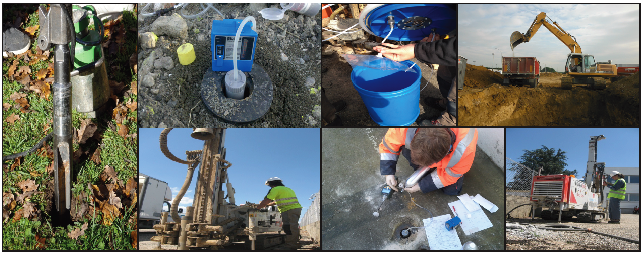
- designing and monitoring of investigations, controls or surveillance programs (CPIS),
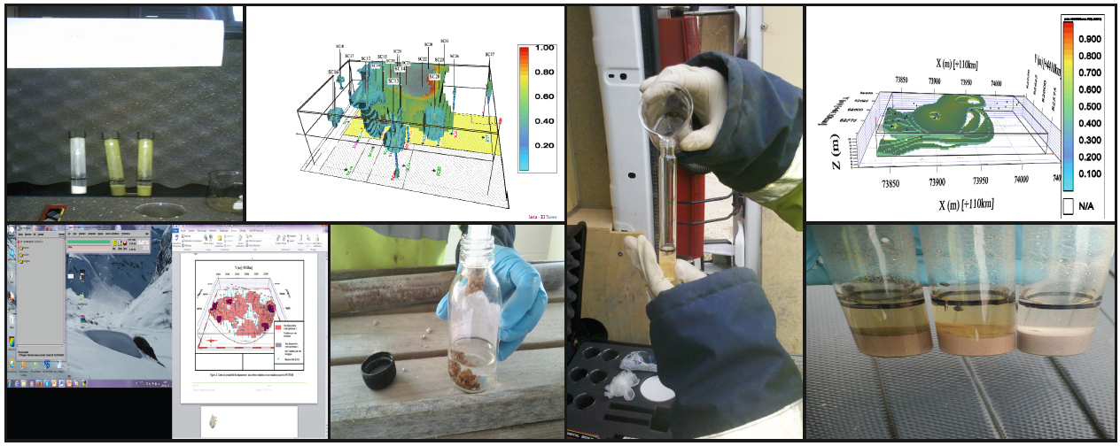
- sampling, measurements, observations, analyses of various environments: soils, groundwater and surface water, sediments, underground gas pockets, ambient air and atmospheric dust, foodstuffs (A200, A210, A220, A230, A240, A250),
- categorising local background noise and interpreting results,
- intervention and sampling on earthwork sites, categorising the excavated soils (A260),
- studying the issues in terms of water and environmental resources (A310),
- analysing health-related challenges, quantitative assessment of health hazards (A320-EQRS) and analysis of residual risks (ARR),
- cost-benefit analysis(A330),
- management plan (PG),
- drafting the documents relating to use restrictions or easements (A400),
- assessment of the state of the environments (IEM),
- controlling the implementation of management measures,

CONSULTING AND ASSISTANCE
ENVISOL shares all of its experience to achieve top levels in terms of environmental, human and natural protection, at a reasonable cost.
SITE ASSESSMENT AND REHABILITATION
- Management plan
- Assessment of the state of the environments (IEM)
- EQRS (quantitative assessment of health hazards)
- Defining the treatment lines, cost-benefit analysis
- Defining risk control solutions – ARR (Analysis of residual risks), defining useful measures to avoid heavy remediation work
- Documentation relating to use restrictions or easements
- Third party expertise
PROJECT OWNER ASSISTANCE – AMO
ENVISOL works with you, offering advice as you design your project, helping you monitor progress, and taking into account the issue of environmental pollution at the earliest stages of the project.
- Organising the situational analysis
- Ensuring that the analysis of the site or of a territory is conducted globally, according to the results of the situational analysis
- Assisting you in your rehabilitation projects, from the initial design to the final acceptance of the work
ENVIRONMENTAL EXPERTISE
- Due diligence audit
- Transfer/acquisition audit
- Initial state in the context of your regulatory documentation
- Site rehabilitation report and activity termination documentation
- Drafting the initial report required under IED guidelines, including investigations conducted under standard NFX 31-620-2
- Completion of regulatory documents ICPE (DDAE, document on water-related legislation…)
- Feasibility and sizing studies for autonomous sanitation

PROJECT MANAGEMENT
When the cost/benefit analysis indicates that rehabilitation works have to be undertaken, it then becomes necessary to integrate the work in a real context that often depends on space and time requirements. In these cases, you will be impressed by ENVISOL’s responsiveness, and by our expertise and our ability to integrate the rehabilitation work in a broader context, allowing us to successfully complete these operations.
- securing the decontamination goals or the chosen management solution(s),
- sizing the treatment systems to ensure feasibility,
- helping you in your relations with other stakeholders: communities, decision-makers, architects, associations, residents, financiers…
- full project management operations, from the initial company consultancy until the final acceptance of the works,
- you have full control over the implemented treatment techniques and over decontamination costs,
- implementation and monitoring of decontamination work, for on site or off site treatments (identification of suitable companies, with a preference for value-added businesses and a circular economy),
- we work with you until the final acceptance of the work, and provide complete site reporting and operational traceability.

GEOSCIENCES
GEOSTATISTICS
For the purpose of conducting an in-depth diagnosis of environmental pollution, the field data is interpreted and used in a deterministic manner, using geometrical meshing for instance. The interpretation of results, and therefore the mapping and sizing of pollution plumes (volume of associated polluted soils) are hypothetical and highly approximative.
Relying on its experience with some 20 studies completed since its creation, ENVISOL provides its customers with a renowned and powerful tool to achieve a more accurate processing of the data: geostatistics applied to polluted sites and soils.
When is it useful to use geostatistics?
- for the mapping of pollution sources based on decontamination thresholds or acceptance criteria for warehousing businesses,
- to direct the excavation work based on an acceptable risk of contamination presence,
- to complete the earthwork plans that are adapted to the terrain and to optimise the execution of excavation work,
- to optimise additional survey campaigns,
- to determine the uncertainty surrounding volume assessments and to ensure safety during the work phase,
- to rely on control campaigns to determine the efficiency of a treatment, and to compare the achieved results with the expected goals.
This method also enables:
- to interpolate results and therefore to refine volume assessments based on the SPATIAL VARIABILITY of the soil pollution (which is not the case for meshing),
- to model the 3D MAPPING of polluted soils and/or plumes of pollution,
- to calculate the RISK PROBABILITIES of exceeding the decontamination thresholds or, if there are issues affecting the management of rubble, the ISDI acceptance thresholds
- TO ASSESS THE UNCERTAINTY SURROUNDING THE CALCULATION OF NON-INERT POLLUTED SOIL VOLUMES, AND THEREFORE TO ASSESS THE FINANCIAL RISK.
GEOPHYSICS
Envisol masters the main geophysical prospecting techniques used to categorise pollution, to identify water sources (electrical resistivity, spontaneous polarization, electromagnetism) and soil analysis (reflection seismology, geological radar).
Our geophysical services pertain to the identification of soil contamination (plume of hydrocarbon pollution, solvents…), of pockets, networks or the presence of historical buildings.
The data stemming from geophysical methods is analysed and used by ENVISOL’s specialised team of experts. Envisol’s innovations make it possible to statistically use the geophysical data and therefore to optimise the modelling and mapping.
HYDROGEOLOGY
ENVISOL’s know-how in terms of hydrogeology covers the following missions:
- hydrogeological studies, pumping tests,
- Design, sizing and implementation of a network of piezometers (CPIS)
Piezometric monitoring and control of groundwater quality, - Tracing tests,
- Four-yearly report – monitoring the management plan,
- Modelling the flow of groundwater (Modflow),
- Modelling the transfer of chemical and radiochemical pollution, taking into account or excluding the saturated area,
Preparing the funding appeals sent to Water Agencies, - Various impact studies,
- Ensuring compliance of water supply catchment protection perimeters,
- Water legislation documents